Showing posts with label Google Earth. Show all posts

Saturday, November 17, 2007

Google Earth Update Leicester


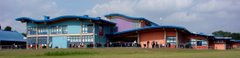
After the improvement to Leicester's coverage in Google Earth we were still left with imagery that was seven years old. Now this has been updated with images that are just a couple of years old. You can now clearly see the blue roof of the school(still under construction) and Bradgate Park in the distance. Notice the sky now has clouds, this is because Google Earth has a new weather layer which is updated in near real time, but much more detailed than the overlay we have used in class. Could be useful for the year 8 weather benefits and hazards project.

Friday, September 28, 2007

City Model


In year 7 we are looking at whether the city model can be applied to Leicester using Google Earth. The KMZ file can be downloaded here. If you want to check the powerpoint just click above or click on the link for full screen. We found that Leicester does fit the city model surprisingly well though Oadby was perhaps an exception. Some sets got as far as discussing the changes we could make to the model so it explained Leicester more fully.

Wednesday, July 11, 2007

Make your own planet.


Lots of you have asked for the file to make a larger version of the Blue Marble globe from lessons. Click here to open the PDF file ready for printing.

Alternatively try a model of the Ozone layer (click here) , or the continents (click here). If you want a further challenge why not create an origami globe (a good chance to brush up on your paper folding skills if you are in year 9!)

Tuesday, June 19, 2007

Lightning in Google Earth


We don't normally feature Google Earth layers on this blog, but this one has to be mentioned since we have now had 2 days of lightning in the past week. Its a layer from GuiWeather.com that shows you live lightning updates worldwide. As lightning swept across Leicestershire tonight from the south I was able to watch its arrival on Google Earth as it homed in on the Bushloe summer concert (being held outdoors). To get the layer just make sure you have Google Earth installed and click on this link for the KML file.

Tuesday, June 05, 2007

Google Earth updates AT LAST!!!!


At last what we have been waiting for since Google Earth first changed our view of the world; decent quality imagery! Leicester has been included in the latest update and Wigston has been given especially good quality coverage. It isn't all good news though, see if you can work out how old the images are, judging from the car outside my old house I would say about 7 years at least. We may have to wait a little longer for the new school to feature (for those in year 6 the image is centred on the old Bushloe) but at least we can tell its out of date now!

Friday, February 02, 2007

General: Google Earth Mystery


A couple of weeks ago we posted a mystery image from Google Earth. In fact it showed the shadows of trees cast on the River Thames in London, clearly the sun was low in the sky though the shadow shows the sun was still in the south. What could this tell us about the time of year it was taken? (Over to you year 9!). It should also remind us that these are images and not maps. Year 6 may want to think about the differences.

Thursday, January 18, 2007

General: What is this?


Clue: It's from Google Earth, but what is it and where is it from?